A recent study from POSTECH (Pohang University of Science and Technology), headed by Professor Hyung Joo Lee and doctoral researcher Na Rae Kim, assessed the effectiveness of ground-based monitoring systems in representing nitrogen dioxide (NO2) levels.
2
) exposure and how this exposure changes with different socioeconomic statuses across South Korea.
The study group calculated the nitrogen dioxide levels at ground level.
2
Concentrations utilizing satellite remote sensing data with a 500-meter spatial resolution played a crucial role in their analysis. These results have been published recently.
published
in the journal
Environmental Science & Technology
.
NO
2
is a criteria air pollutant primarily emitted from combustion sources, such as on-road and off-road vehicles and power plants. It is regulated under South Korea’s Clean Air Conservation Act due to its association with adverse health effects, particularly on respiratory health. Because NO
2
With its brief atmospheric lifespan and tendency to react quickly with other elements in the atmosphere, precise exposure evaluation requires spatially detailed data.
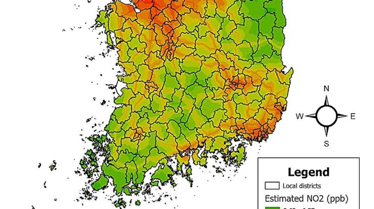
However, ground monitoring networks are not evenly distributed, making it difficult to represent population-level exposures adequately. To address this challenge, the POSTECH team employed satellite remote sensing NO
2
data from the Tropospheric Monitoring Instrument (TROPOMI), resulting in a comprehensive spatial map of NO
2
exposure across the country with a 500-meter resolution.
Utilizing this detailed data, the scientists evaluated if the nationwide ground monitoring network effectively measured people’s exposure to nitrogen dioxide.
2
In urban areas across various regions, since the ground monitoring data serve as reference points for assessing adherence to air quality regulations, it’s essential to guarantee these figures accurately represent actual environmental exposures.
The research showed that ground monitors provided lower readings of NO
2
Exposure levels were increased by up to 11% in Gangwon-do (located in the northeastern area of South Korea), whereas they were overestimated by as high as 61% in Jeju-do (which is the biggest island in South Korea). Additionally, the effectiveness of ground-level monitoring did not significantly correlate with the quantity of installed monitors within a specific region. This implies that simply increasing the monitor count might not enhance precision when gauging overall public exposure.
The research additionally looked at the variations in NOصند
2
Exposure differences across socioeconomic statuses within various regions were analyzed. The findings indicated that locations characterized by elevated socioeconomic standings, as measured through average home values and individual insurance premium costs, exhibited greater NO2 concentrations.
2
This conclusion was reinforced by persistently positive correlations, which ranged from 0.53 to 0.92 for house values and from 0.41 to 0.91 for insurance costs.
Interestingly, this differs from earlier observations in other nations, where socially marginalized communities frequently face greater exposure to nitrogen oxides (NOx).
2
The researchers linked this discrepancy to South Korea’s distinct trajectory of economic growth.
In the swift industrial growth during the 1970s and 1980s, significant roadways and living spaces were developed closeby. Being near these routes became desirable due to easier travel options, which boosted the need for homes and consequently increased property values.
Moreover, during the 1970s, the government set up industrial complexes across various regions of South Korea, attracting numerous jobseekers who then turned these locations into centers for well-paid jobs. Consequently, affluent communities have clustered in zones with increased NO2 levels.
2
air pollution today.
Professor Hyung Joo Lee stressed, “The strategic positioning of ground monitors, taking into account both pollution hotspots and population distribution, is crucial for accurate exposure assessment.” He further noted, “Our research primarily concentrated on NOx levels.”
2
Additionally, other airborne contaminants should be assessed to foster a more thorough comprehension.
Since the effects of air pollution on health are shaped by elements like healthcare facilities, local surroundings, and pre-existing health issues, an integrated and multifaceted strategy is essential for comprehensively grasping and tackling the public health consequences of air contamination.
More information:
Na Rae Kim et al., Utilizing High-Resolution Satellite-Based NO2 Data
2
Estimates to Evaluate NO
2
Exposure Representativeness and Socioeconomic Disparities,
Environmental Science & Technology
(2025).
DOI: 10.1021/acs.est.4c10996
Provided by Pohang University of Science and Technology
This tale was initially released on
Dailyexe
. Subscribe to our
newsletter
For the most recent science and technology news updates.